

WATCH: Storm Babet sparks multiple Met Office weather warnings for heavy rain and gales in the Scottish Highlands
Register for free to read more of the latest local news. It's easy and will only take a moment.

Highland residents are being warned to brace for strong gales and "impactful rain" after the Met Office upgraded weather warnings for later this week.
A 66-hour long warning for rain for part of the Highlands had already been issued for Thursday through into Saturday, but on Monday morning the Met Office issued several further alerts for wind and rain – from Wednesday and Thursday onwards.
Two separate rain warnings, and a Highland-wide alert for gales have now been issued in the Highlands, with two other warnings for southern Scotland, northern England and the east of Northern Ireland.
A yellow warning for wind has been issued covering the Highland mainland, Skye, Small Isles, Okrney, Shetland, Moray, Aberdeenshire, Angus and part of Perthshire. It comes into force at 6am on Thursday and ill remain in effect until midday on Friday.
Gusts of up to 70mph are being predicted on exposed coasts and upland areas.
Related: WATCH: Met Office issues 66-hour long warning for rain in part of the Highlands
A spokesman said: "A prolonged period of strong southeasterly winds, peaking through Thursday and early Friday, and coupled with heavy and persistent rain across eastern Scotland in particular, brings the potential for disruption, especially to travel.
"Gusts of wind of 40-50 mph can be expected quite widely within the warning area, but coastal eastern Scotland, Orkney and more locally to the lee of the mountains in the west, could locally experience gusts as high as 60-70 mph. Large waves could be an additional hazard around North Sea coasts.
Meanwhile, rain warnings have been issued for two parts of the Highlands.
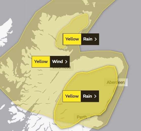
One covers parts of Sutherland and Caithness, and affects an area from the Dornoch Firth up the east coast into Caithness, and extends westward to Loch Shin and almost as far north-west as Loch Naver and Loch Choire.
The alert will be in force from 6am on Thursday until 6am on Friday.
Commenting on this first rain alert, a Met Office spokesman said: "Whilst there is still some uncertainty in the details, there is potential for a period of heavy and persistent rainfall to develop on Thursday, lasting into Friday.
"The highest rainfall totals, perhaps in excess of 70 mm, are most likely over east-facing high ground, but some heavy rainfall is likely at lower elevations too. Very strong southeasterly winds, with gusts possibly exceeding 60 mph, could exacerbate any impacts."
The second warning for rain, meanwhile, covers parts of Badenoch and Strathspey – including Aviemore and Kingussie, where severe flooding was experienced earlier this month.
The alert area also extends east across much of Aberdeenshire and all of Angus and south as far as Perth and Stirling.
It will be in place from 6am on Thursday until midday on Saturday.
Commenting on this alert, the spokesman added: "The heaviest rainfall is more likely to occur over Angus and southeast Grampian, although even lower lying areas could see unusually heavy rainfall during this period.
"Widely 70-100 mm of rain is likely to fall, but some upland areas may see as much as 150-200 mm of rain through this period. Strong southeasterly winds are likely to accompany heavy rainfall which may exacerbate impacts."
Whilst there is still some uncertainty in the timing and duration of rain through this coming week, there is potential for disruptive, heavy and prolonged rainfall to affect central and eastern Scotland. The heaviest rainfall is more likely to occur over Angus and southeast Grampian, although even lower lying areas could see unusually heavy rainfall during this period. Widely 70-100 mm of rain is likely to fall, but some upland areas may see as much as 150-200 mm of rain through this period. Strong southeasterly winds are likely to accompany heavy rainfall which may exacerbate impacts.