

New tech including satellites and AI could give more accurate picture of Scotland's deer numbers
Register for free to read more of the latest local news. It's easy and will only take a moment.

Innovative new technologies are being trialled that could help revolutionise the way deer numbers are tracked across Scotland.
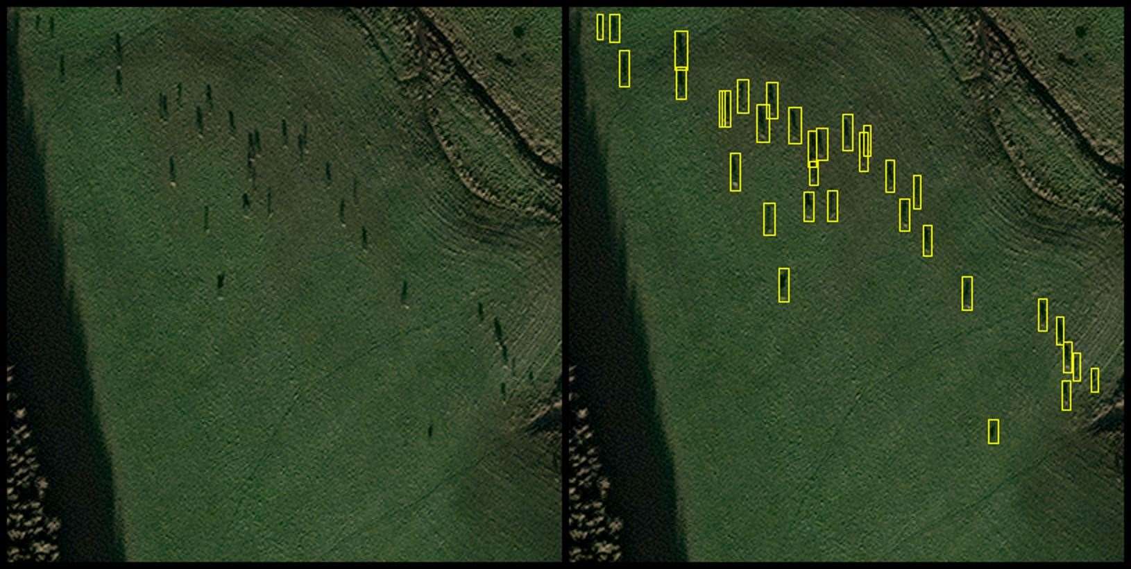
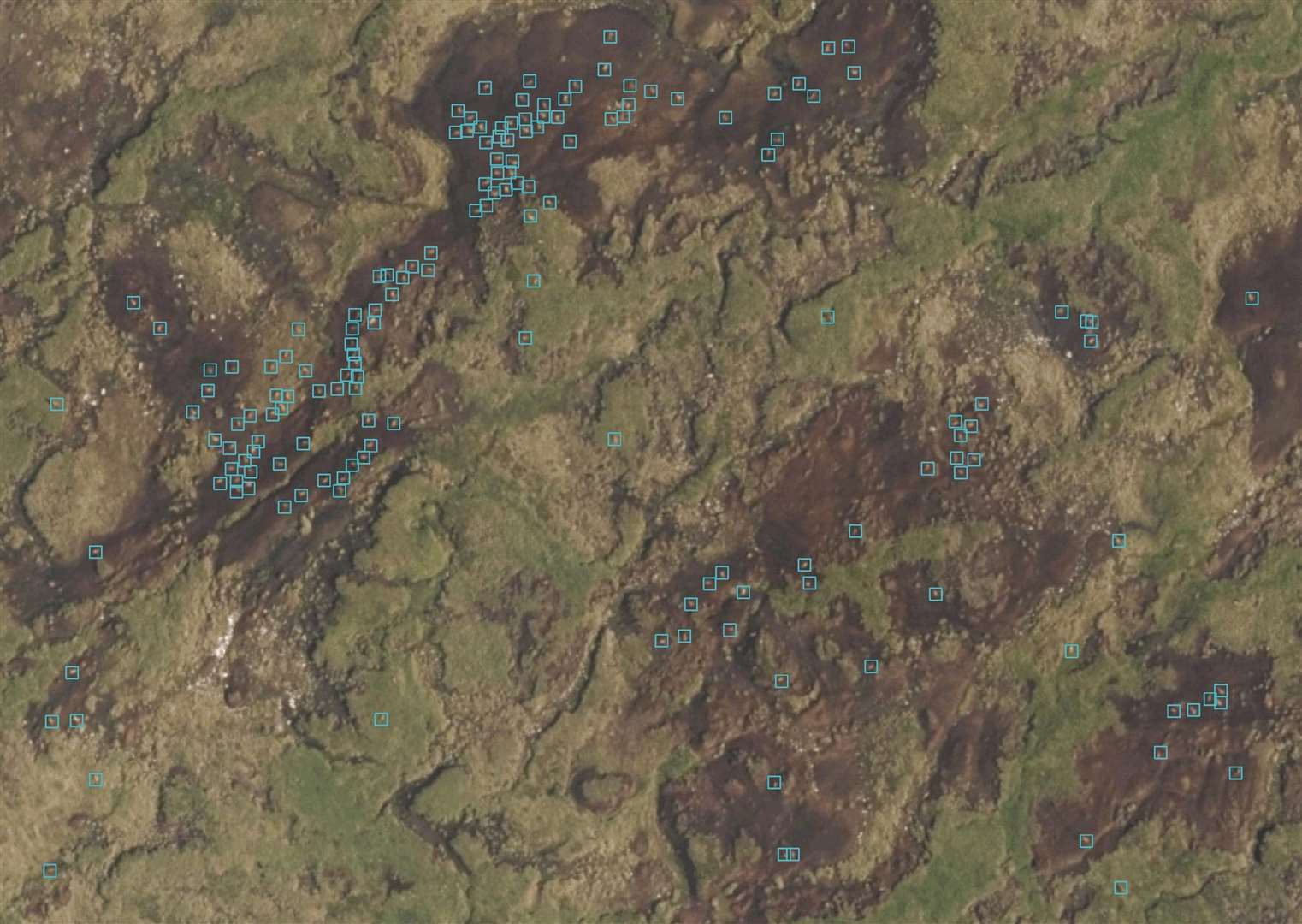
NatureScot is working with Glasgow-based tech company EOLAS Insight to test the use of satellites, aerial imagery and artificial intelligence (AI) to accurately count deer.
Knowing how many deer use an area is important to determine how to manage populations for conservation or sporting purposes.
With many deer counts currently carried out manually by helicopter, new technologies offer an alternative solution that could provide swift and accurate data across large areas while helping to reduce the associated carbon footprint and cost.
There have long been disputes over actual deer numbers between gamekeepers and conservationists with the latter believing figures are too high and damaging too many trees and especially regeneration projects.
Gamekeepers maintain that totals are lower than often claimed and livelihoods are being endangered.
Clashes over culls on public agency land or on private estates with public sector support are not uncommon.
The first phase of the project, supported through the Scottish Government’s CivTech programme, used satellite imagery combined with newly developed AI image recognition software to identify deer in images.
The approach was so successful that the same technology is now being used by EOLAS Insight to help conservationists count African elephants from space.
NatureScot is again partnering with the company to launch a second phase of work, which will further explore the use of aerial imagery.
This involves images from a lightweight manned aircraft, with a high resolution camera system, being run through the EOLAS Insight AI recognition software to automatically count deer numbers.
It is hoped this approach could overcome some of the challenges of satellite use in Scotland, including weather and cloud cover.
While satellites can provide broad overall numbers, a higher camera resolution could allow deer to be classified as stags, hinds, calves and could also be more useful for looking at habitat type and condition.
Lightweight manned aircraft are still significantly greener than helicopters and can cover larger areas.
The automation process could also be applied to aerial imagery that is routinely collected for other agencies, such as Ordnance Survey.
Jamie Hammond, NatureScot’s Regional Deer Operational Delivery Manager, said: “Our trials with satellite imagery have been successful so far, particularly at finding deer in the wider landscape and providing data on total numbers.
"The AI technology that EOLAS has developed has proved that an image recognition system is feasible
“However there are some challenges and limitations, particularly with the Scottish weather as cloud cover and haze can have a negative effect on image quality.
"We’re hopeful that this alternative approach, with better image resolution, will improve the accuracy further and could even identify and classify deer as stags, hinds and calves.
“While we’re not yet at the stage of being able to replace helicopters for the deer census, the technology we’ve been trialling has huge potential.
"We hope that in the near future these approaches could provide an alternative solution to count deer accurately while cutting our carbon footprint and costs.”
Douglas McNeil, Managing Director at EOLAS Insight, said: “The need for lower emissions methods of monitoring wildlife populations is critical for the net zero transition.
"Our work with the wildlife management team at NatureScot has been crucial in demonstrating how AI and imagery can be used to remotely monitor wildlife populations, without disturbing their pattern of life.
"This approach will be adapted in future to also support the automated detection of degraded peatland and assessment of sites for new woodland, for which deer density is a key risk factor.
"We are hugely appreciative to all at NatureScot for their support in developing this cutting edge service.”
A NatureScot spokespersons said: "Deer are an iconic species in Scotland and form an important part of our biodiversity.
"But their high numbers and lack of natural predators mean they can have a negative impact by browsing on woodlands and other habitats.
"The sustainable management of Scotland’s deer, including a significant reduction in numbers, is vital to deliver on protecting and restoring nature and meet Scotland’s net zero targets."